
Responsibilities
Primary & Secondary Research,
Stakeholder Interview,
Journey Mapping & Persona Generation
Brainstorming & Ideation,
Concept Generation,
Wireframing,
Prototyping,
3D Modelling,
Testing &Validation.
Team members
Amrutha Anup
Mentor
Deval Karia
Duration
6 Months
Tools
Figma, Blender
Commute & Connectivity
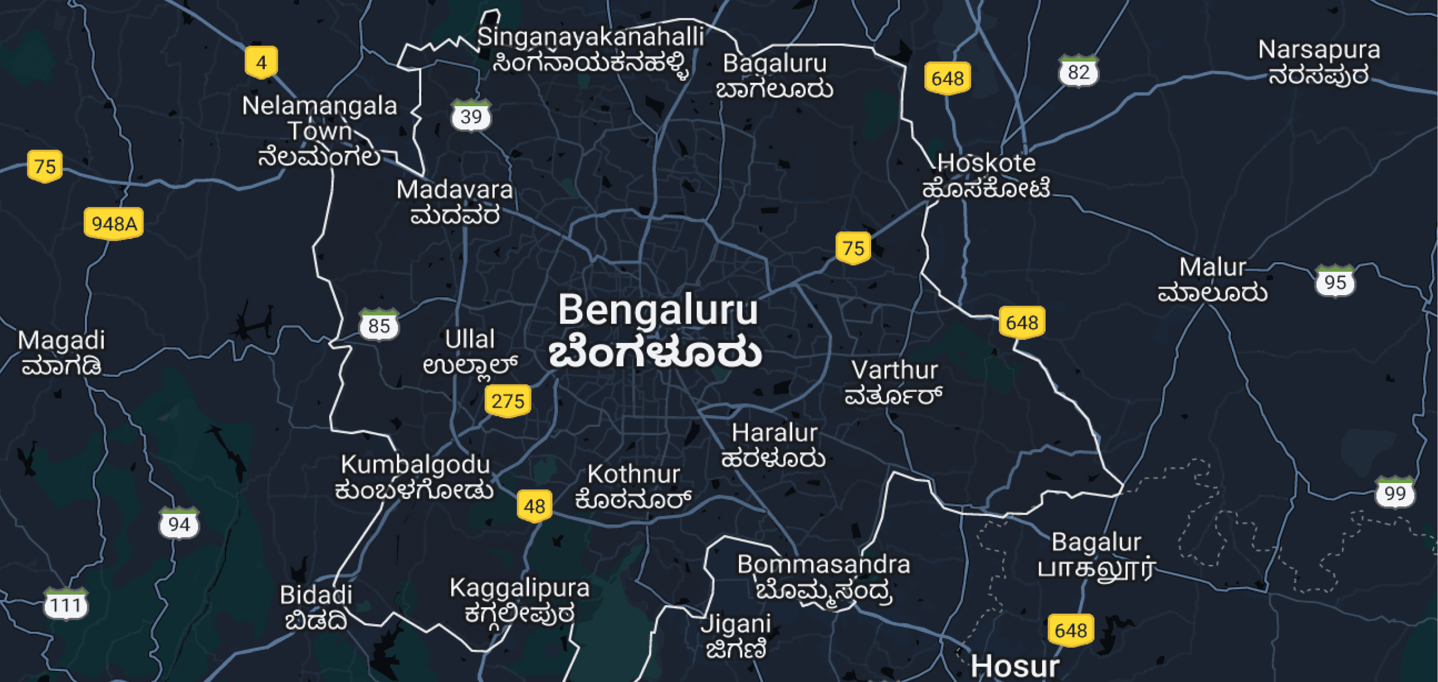

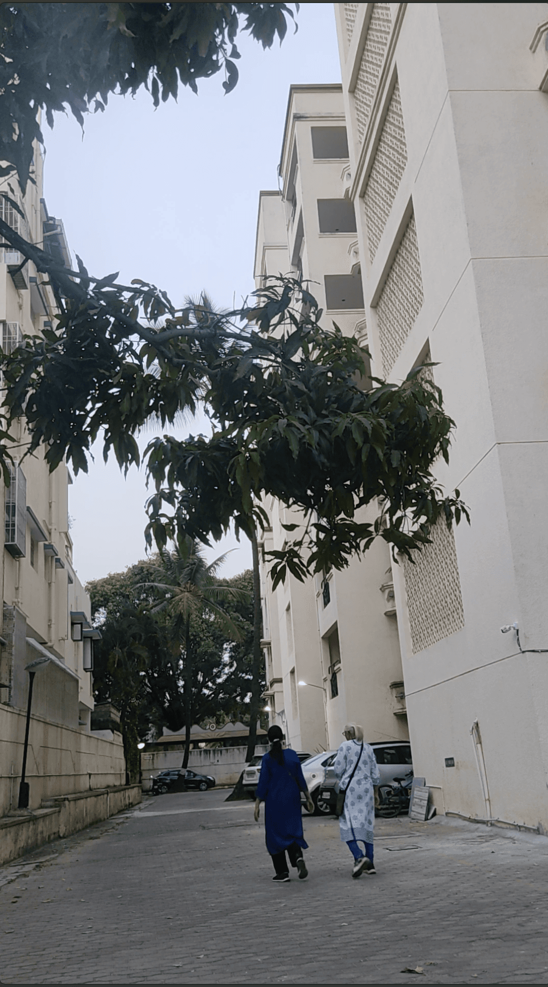
In 2022, The expanding metropolitan city of Bangalore had reached its vehicle capacity and claimed the 6th rank of most traffic congested cities worldwide. As college students who faced the problem on a daily basis, we decided to do something about it by proposing a futuristic solution.
Project Overview
This project tackles the increasing levels of vehicle congestion commuters face in Bangalore city by suggesting a system based solution that lasers in and counters the various individual problems that lead to congestion.
To accomplish this we identified our core users and prioritized them based on impact. We then conducted extensive user interviews to understand congestion at different levels.
Based on our findings we highlight the importance of pedestrian centric infrastructure and its benefits in mitigating traffic and equally distributing space for commuters.
We chose Bengaluru as our mega-city to improve the movement and commuting system because with 6 million private vehicles on the the road and poor city planning the people loose up to 22 minutes of their time everyday in traffic congestion.
#2
Bangalore
World Rank
Most Congested Cities, 2022
3822
Road accidents
2022
243
hours per
year
Spent in traffic
2022
COntext
Bangalore had seen a steady rise in traffic from the years prior. Trips 5 kms apart would take 30 mins to complete with the chaotic blend of narrow roads, bottlenecks, construction, faulty signals, a sprinkle of torrential climate creating obstacles for daily commuters.
The current initiatives by the government have either been short term solutions, currently in development or inefficient solutions that can’t catch up to the city’s booming demands. We realized that any long term solutions for this problem, just like Rome, couldn’t be built in a day. Therefore, after understanding the complex issue at large we’re proposing a solution that aims to save the congested city in the foreseeable future.


Outcome
We designed a city wide system that aimed to mitigate traffic and its subsequent problems in numerous sectors. This system includes:
An enhanced and expanded public transport system that transport users across the city and is able to reach remote, rural areas with the help of smaller feeder vehicles.
Supporting infrastructure that provides public and non motorized transport users with shelter, information transparency and amenities, in the form of improved bus stops, signages and commercial spaces to incentivize and facilitate it’s use.
Integration of smart technology to accommodate usage of multiple users, motorized or otherwise, on roads, highways, intersections and pathways.
Providing safe and communal spaces for pedestrians and other non-automobile users to commute in peace, away from vehicles.
Objective
To effectively reduce traffic and allow pedestrians and motorists to commute with ease.
How might we reduce traffic, bring more space to pedestrians and create a system that eliminates traffic entirely?

Application Screens
Kiosk Screens


Attention!
You need to drive at a constant speed of 40km/hr to stay within the green cycle!
35
km/hr
SPEED TRAVELLING
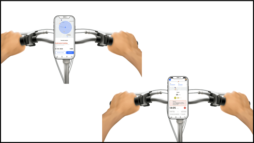

SMART APP INTEGRATION
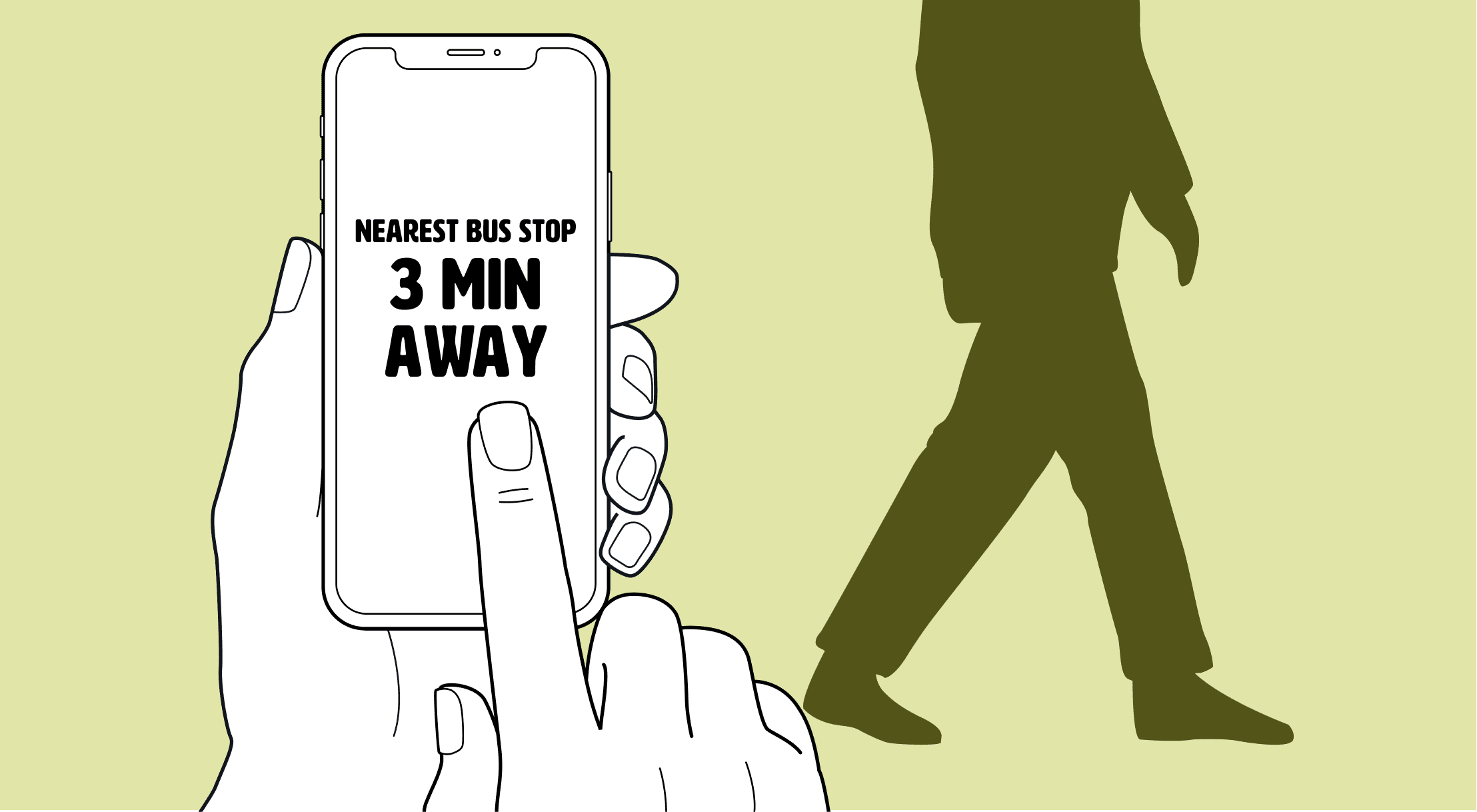
Public Transport: Provides accurate real-time information regarding bus routes, timings, ticket fares and traffic report.
Cyclist: Provides disruption free routes by suggesting areas with fewer vehicles, scenic routes and ample stops for refreshments. It also alerts cyclists when they are too close to vehicles to ensure safety.
Pedestrians: Displays health stats and positive health benefits, areas to visit, various modes of transport to opt for, rewards and tokens that can be exchanged in shops, all as a means of incentivization.
Private Vehicles: Displays information about the optimal speed to align with the green wave in signals, and in residential areas. Fines are immediately recorded if the vehicle parks on a pedestrian pavement, bus or cycle lane.

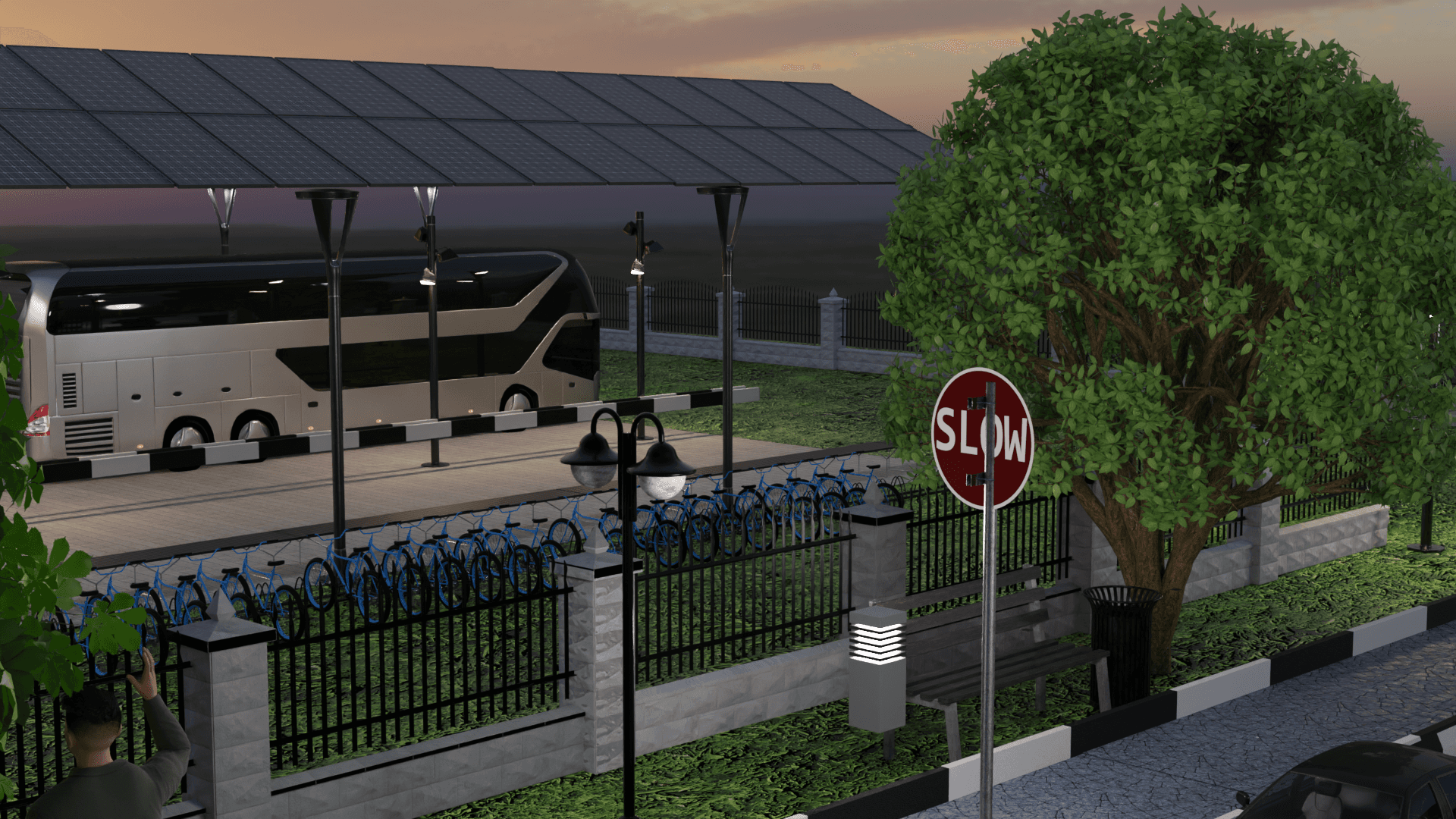
Improved public transport
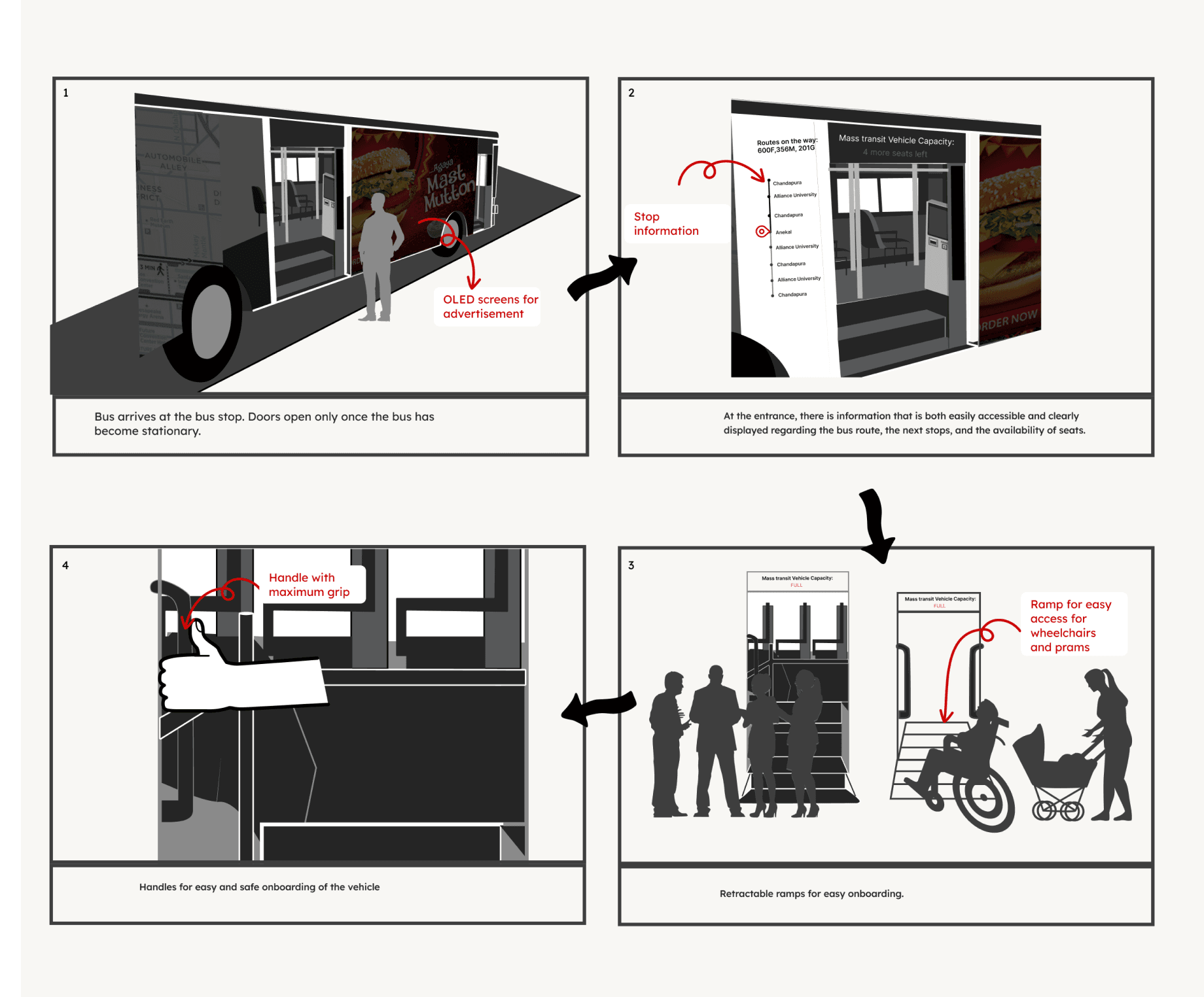
Enhancing the existing public transport system. Along with an overall improvement in efficiency and form, the major improvements were:
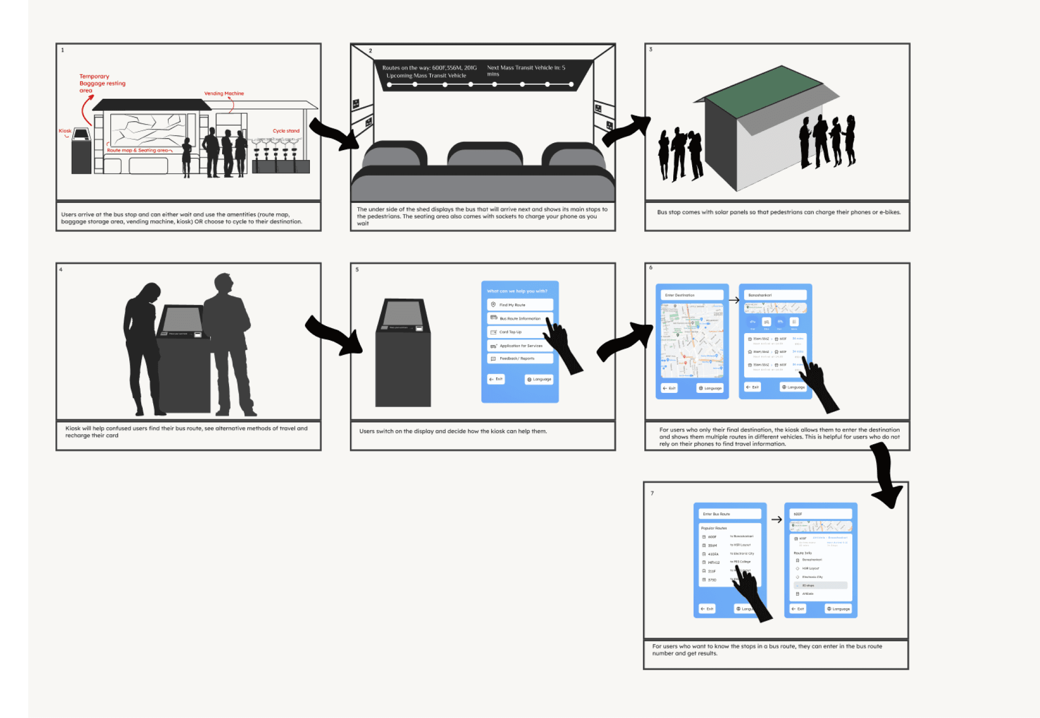
Information Transparency: Introducing smart kiosks and interactive displays that clearly display real-time live travel routes, timings and services.
Scheduling: Tracking technology that monitors buses and feeder systems and provides live information to the users.
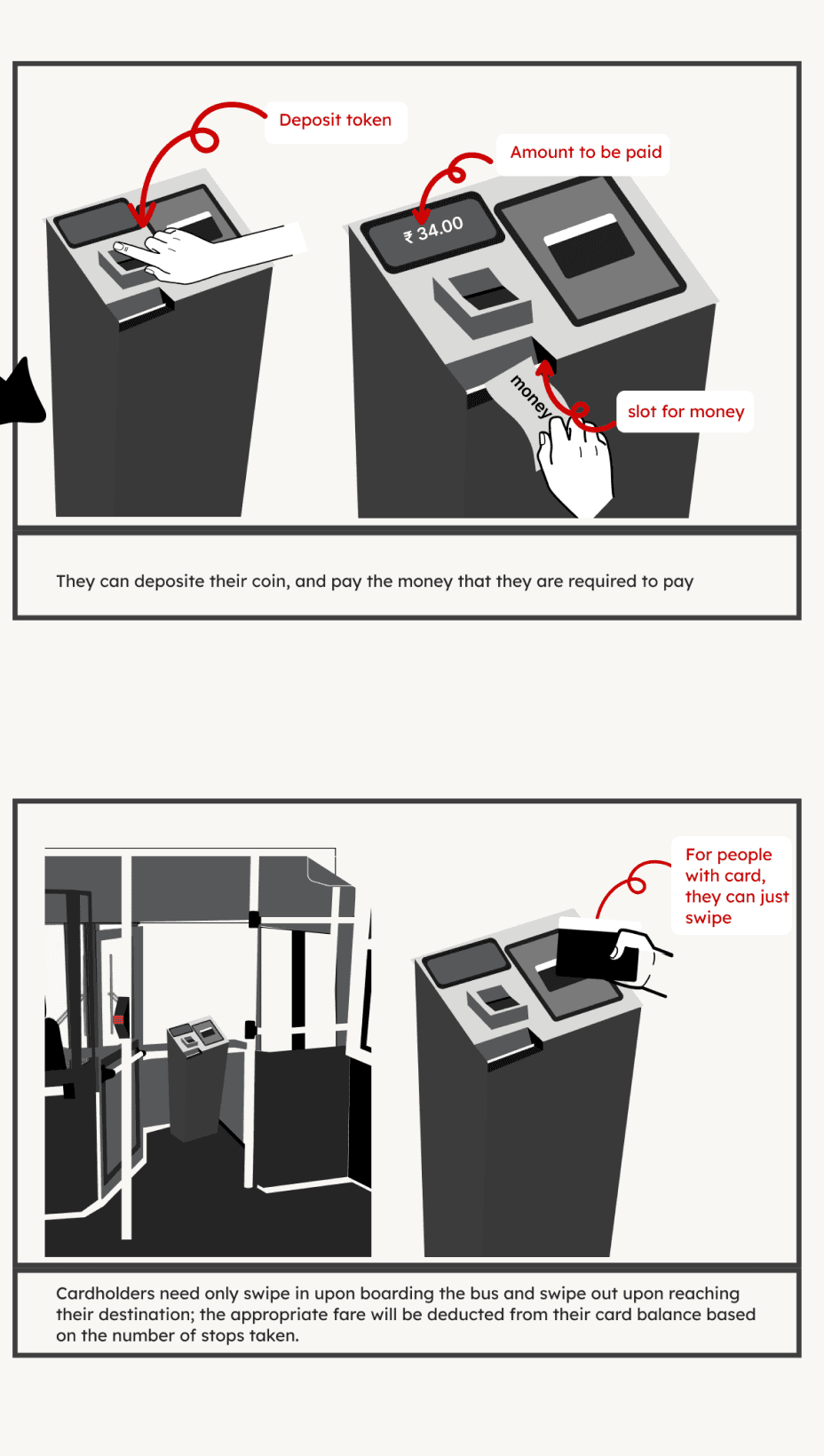
Smart Ticketing: Integration of QR codes along with more efficient ticket collecting technology.
Comfort & Safety: Inclusion of extra support, segregated seats, increased friction, emergency stop buttons and storage compartments.
Accessibility: Dedicated spaces for wheelchair users as well as low floors and smart ramps are included.

FEEDER SYSTEMS
Feeder System: To ensure accessibility of all regions, the public buses work together with smaller feeder buses that transport users from their rural, remote areas to nearby bus stops or metro stations.
The feeder systems have most of the same features as the buses. The location of these buses is also tracked and recorded for other users to get live information.
Carpooling Stations: Feeder stations and bus stops also have carpool stations where users going to similar places can ride together.
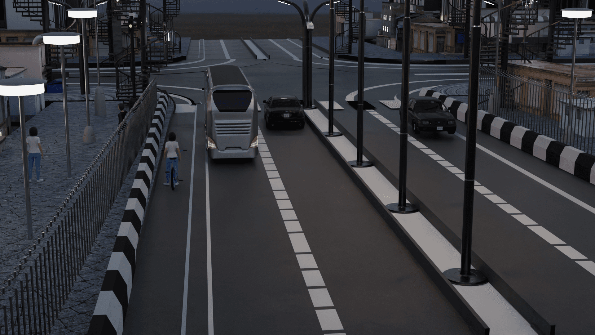
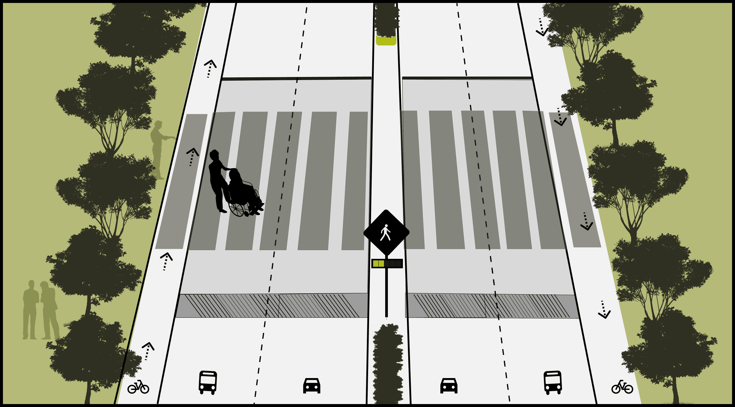
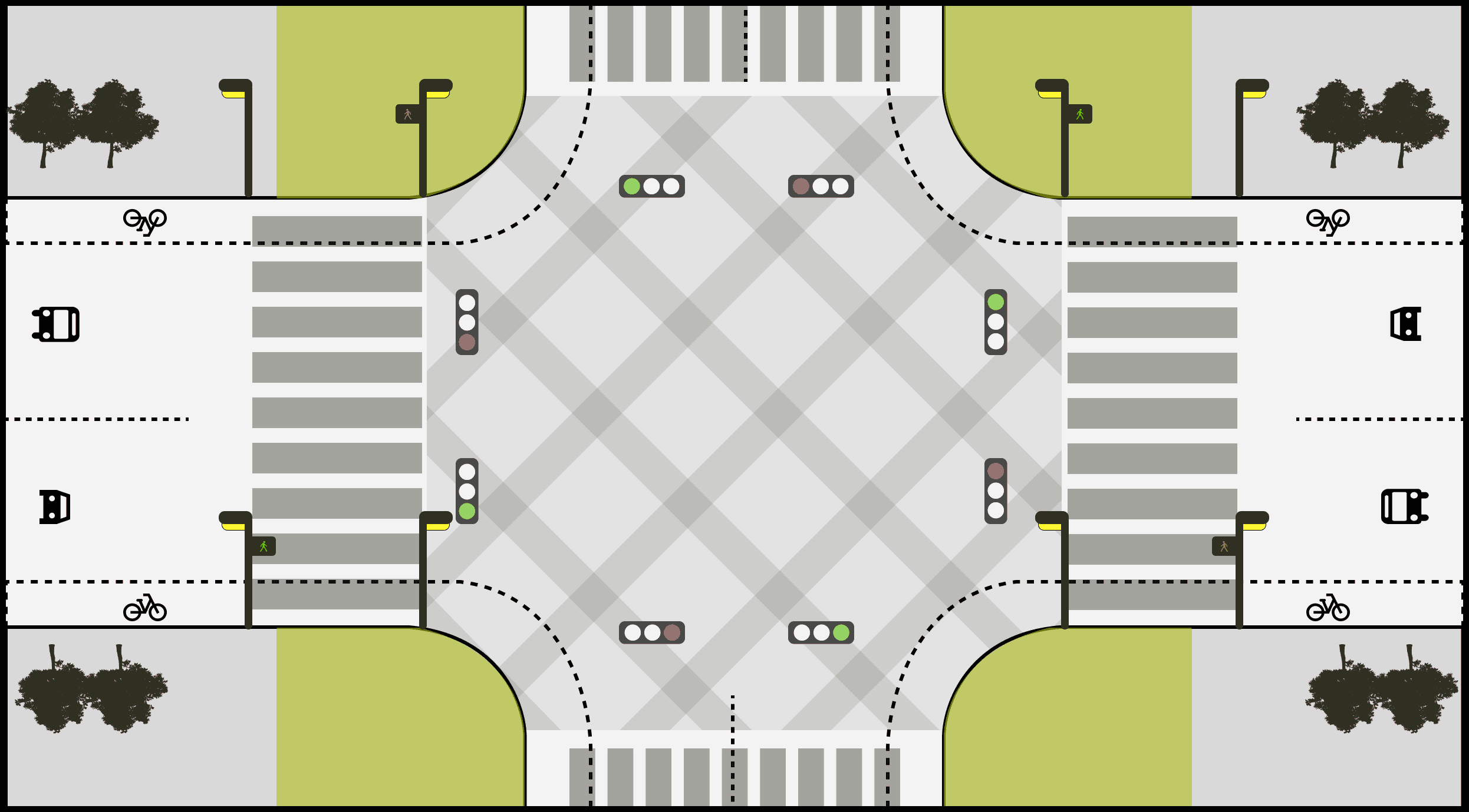
ROAD REDESIGN
Segregated Lanes: Separate Lanes for Cars, cyclists and buses, as well as a defined pathway for pedestrians. This increases safety for all users and encourages them to shift to either pubic transport or non motorized transport.
Accessibility: Inclusion of ramps, skywalks and tactile roads that safely guide visually impaired and disabled users while crossing the road.
Smart technology: Pedestrian crossing sensors, smart intersections and supporting surveillance and tracking technology ensures safety of all users. Green wave signals are also more frequent for public transport and cycling lanes as a form of incentivization
Infrastructure: Extended pavements and corridors to reduce road space and cognitively alert drivers about their entry into residential areas which reminds them to drive slow.


INTEGRATED INFRASTRUCTURE
Making spaces that accommodate both motorized transport users and motor vehicle users. With clearly separated pathways for pedestrians, cyclists and public transport.
Exclusive areas just for pedestrians so as to increase safety and comfort of walking and cycling without the disruption of vehicles.
Inclusion of smart technology that alerts drivers when pedestrians are nearby and crossing roads.
All of this ensures that vehicle and non vehicle users can co-exist in harmony.
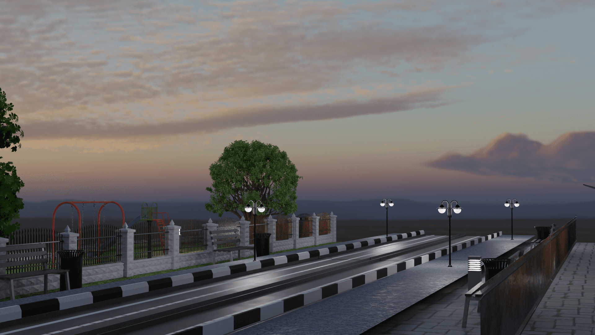

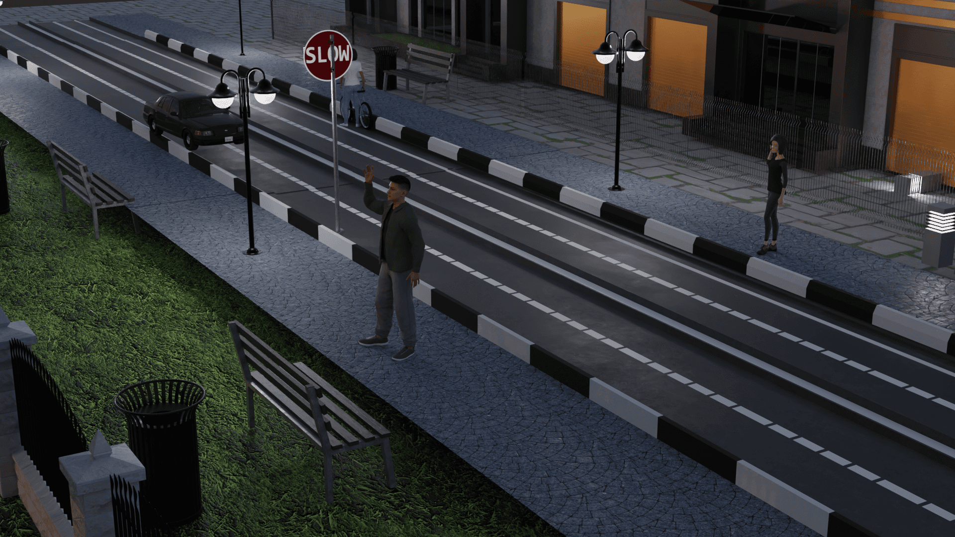
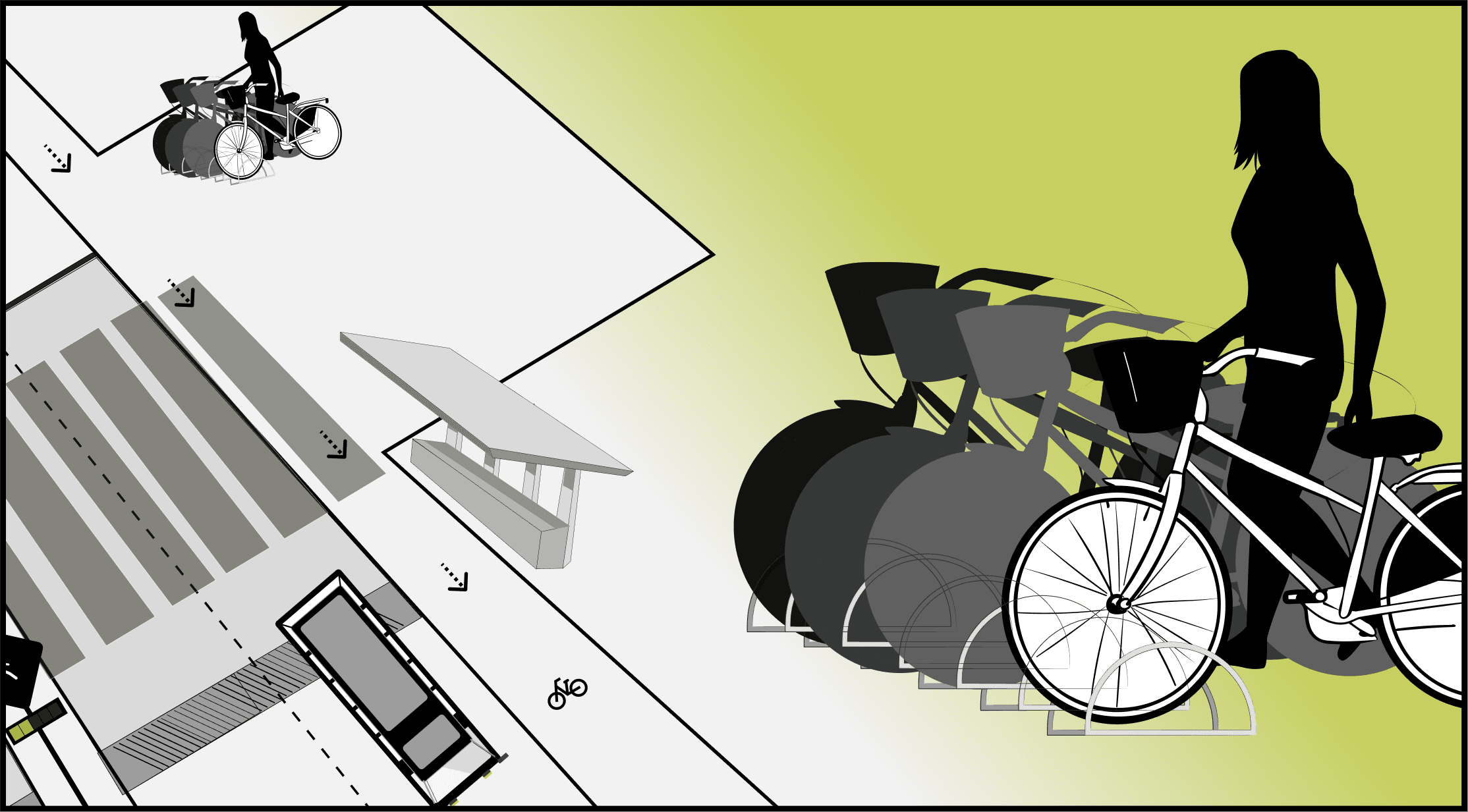
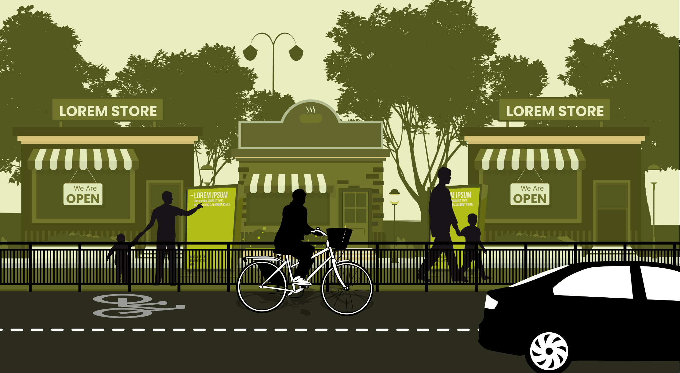
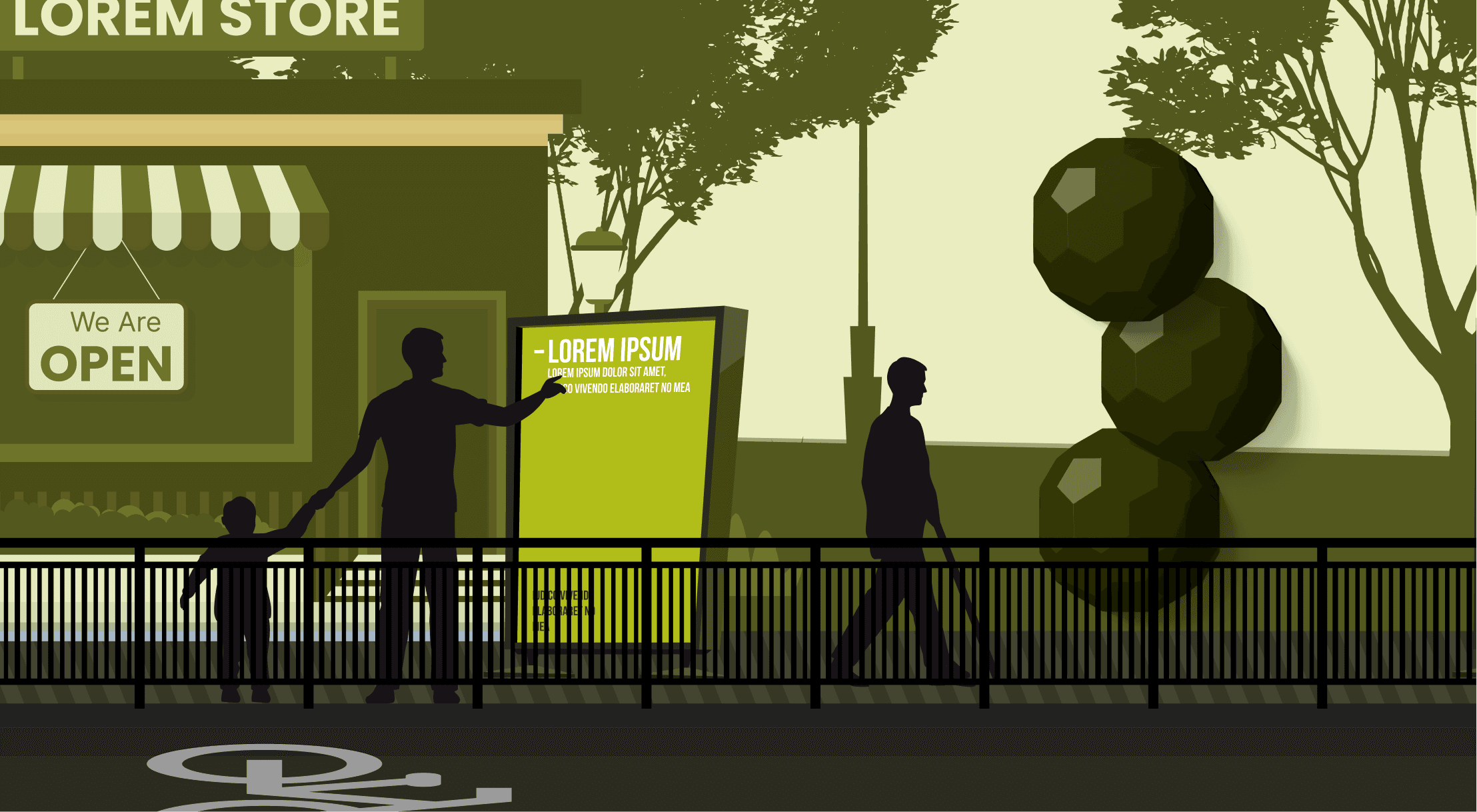
Nmt INFRASTRUCTURE
Pedestrian Spaces: Designated spaces for pedestrians to walk in, interactive sculptures and displays to engage with.
Seating: Increase in well established seating areas with weather protection, charging stations and greenery.
Commercial Spaces: Increase in local commercial centers for refreshment, repair, etc. that encourage community gathering and endorse walking and cycling.
Cycle stands: Bikes and scooter sharing services stationed across spaces for use when required.
Greenery: Ample dispersion of tall trees to freshen up the air, provide shelter and increase breathability in the city.
limitations
This project can only be implemented in a future scenario where the government bodies are able to finance and maintain the design intervention across the city. To aid its implementation, we decided to build on the existing infrastructure and facilities provided by the government.
Our primary research and testing sample consisted of over 50 stakeholders across various transportation modes. This is a minute number compared to the city’s population. This may bring up additional road blocks in further rounds of testing and validation. To minimize this we made sure to interview numerous distinct users and get their insights.
The city’s planning and implementation of infrastructure has been irregular and is distinct in different sections of the city. This means that given the existing conditions, it may be difficult to implement the design intervention in certain areas with no space for improvement. However, implementation on the more accessible areas of the city will still provide impact, ease commute for its users and ultimately mitigate congestion.
learnings
Through this project, We were able to leave the restrictions of an app as an end all be all solution to complex interwoven issues. We were able to expand my horizons and touch upon a more holistic, systemic, experience based solution that helped us analyze each aspect of the problem and solution through a new lens.
At various parts of the design process, I learnt to step into the shoes of all the stakeholders involved and consider how the problem and solution would impact each of them differently.
We learnt to state clear project agendas at the beginning of the project and constantly communicate with each other so as to stay on the same page, work collaboratively and stay on top of deadlines.
Narrow down one
problem to a specific
root cause
Why and How Laddering
Interview
Survey
Insights
List of
Requirements
Idea4
Idea3
Conceptualisation & Morphological Matrix
(Specific details about
chosen idea)
specific 1
specific 2
specific 3
specific 4
Design Intervention
Specifics
Concept
Final Prototype
Idea2
Idea1
Brainstorming
Idea5
Idea6
Stakeholder Map
Jobs, Pains, Gains
Draft
SNPS
Research
What problem
can I try to Solve?
What domain should I choose?
credit: Deval Karia
What is the exact problem I
am trying to solve?
What do I know about
my problem?
What should
my design intervention do?
How do I try and
address the problem?
What does my Design
Intervention look like?
What exactly does my Design
Intervention look like?
Final Design
Intervention
Problem Area 2
Problem Area 1
Problem Area 3
Problem Area 4
Problem Area 5
Stakeholder archetype 1
Stakeholder archetype 2
Stakeholder archetype 3
Stakeholder archetype 4
Stakeholder archetype 5
Find Primary Stakeholders & create Assumed Journey Map for archetypes
Back and forth between Journey and Exploration to discover the different areas with problems
Define Industry
Review Existing literature studies
Define Habitat and Study
Consult Experts
Pick A Domain
Select user groups
Design Process
UX Tools Used
Why & How Laddering: Breaking down a complex issue by continually asking ‘Why?’ questions until the problem cannot be broken down further.
Every 10 out of 13 people own private vehicles
Population: 13 million
What is driving the majority to make this choice?
research & exploration
Through secondary research we understood that the problem of traffic was caused by a multitude of factors. The key factors that led to traffic are mentioned below.
Poor Maintenance of Roads: Lack of maintenance leads to an increase in the developments of potholes and ditches that can cause accidents and further aggravate congested conditions.
Inefficient Planning of Intersections: The city has 40,000 junctions, with only 398 signal controlled and 600 manually managed during rush hours. Uncontrolled crossroads are a cause of traffic congestion and dangerous crossings, contributing to decreased safety.
Inadequate Public Transport Facilities: Government initiatives to improve the public transport system have been few and far apart. Due to this, the system gradually was unable to accommodate the developing masses.
Lack of Pedestrian Infrastructure: The increasing traffic demands of the city encroached on the limited available pedestrian space. This drove pedestrians to depend on vehicles themselves.

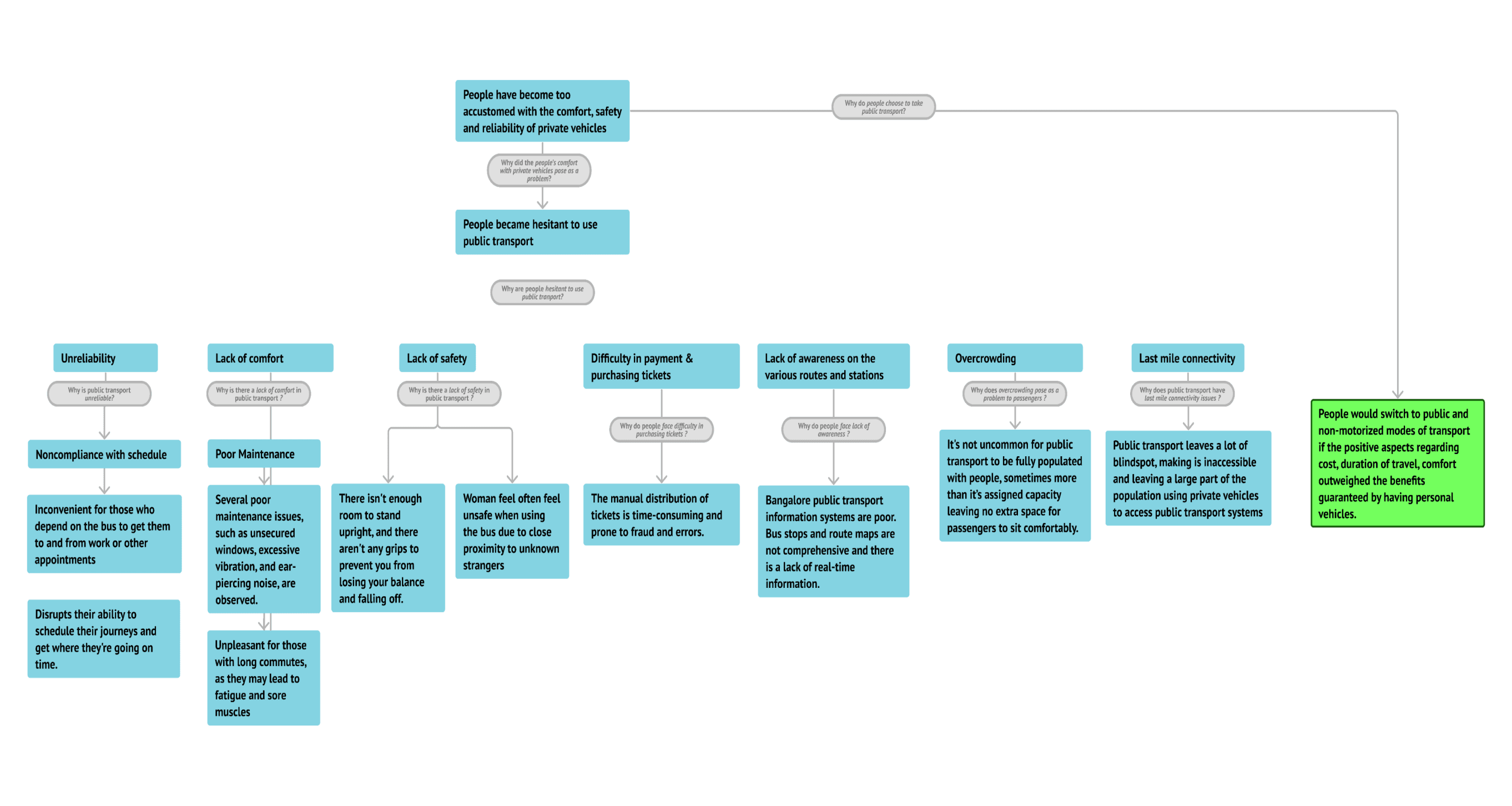
Why & How Laddering
Primary Stakeholders
Pedestrians
Cyclists
Secondary Stakeholders
2 Wheeler Riders & Passengers
3 Wheeler Riders & Passengers
4 Wheeler Riders & Passengers
Disabled Travellers
Tertiary Stakeholders
Police Officers
Vendors
Government
Urban Planning Individuals
stakeholder Mapping
After identifying our stakeholders we divided them into 3 categories.
People using non motorized modes of transport
People using public transport
People using motorized modes of transport
We gathered insights from over 50 stakeholders in the form of interviews, habitat studies, focus groups and surveys.
Prioritizing our stakeholders in this order helped us to ensure that our intervention would focus on remaining pedestrian and non motorized transport centric based. This would decrease the space provided for private vehicles and cause a shift the user base from private to public modes of transport.
2 Wheeler Riders & Passengers
Police Officers
Vendors
Government
Urban Planning Individuals
4 Wheeler Riders & Passengers
Pedestrians
Cyclists
Disabled Travellers
Ambulance drivers
3 Wheeler Riders & Passengers
Stakeholder Mapping
Journey Mapping & Persona
We used user journey maps to consolidate, in detail, the various aspects and issues present in the lives of our primary stakeholders while commuting across the city.
Documenting the uncovered insights in this format helped us put their daily struggles and pain points into perspective.
User journey maps and personas also help to capture the core problems of a representative group in a short glance.
These tools then help us keep track of the users core needs as we proceed further into the brainstorming and ideation phase.
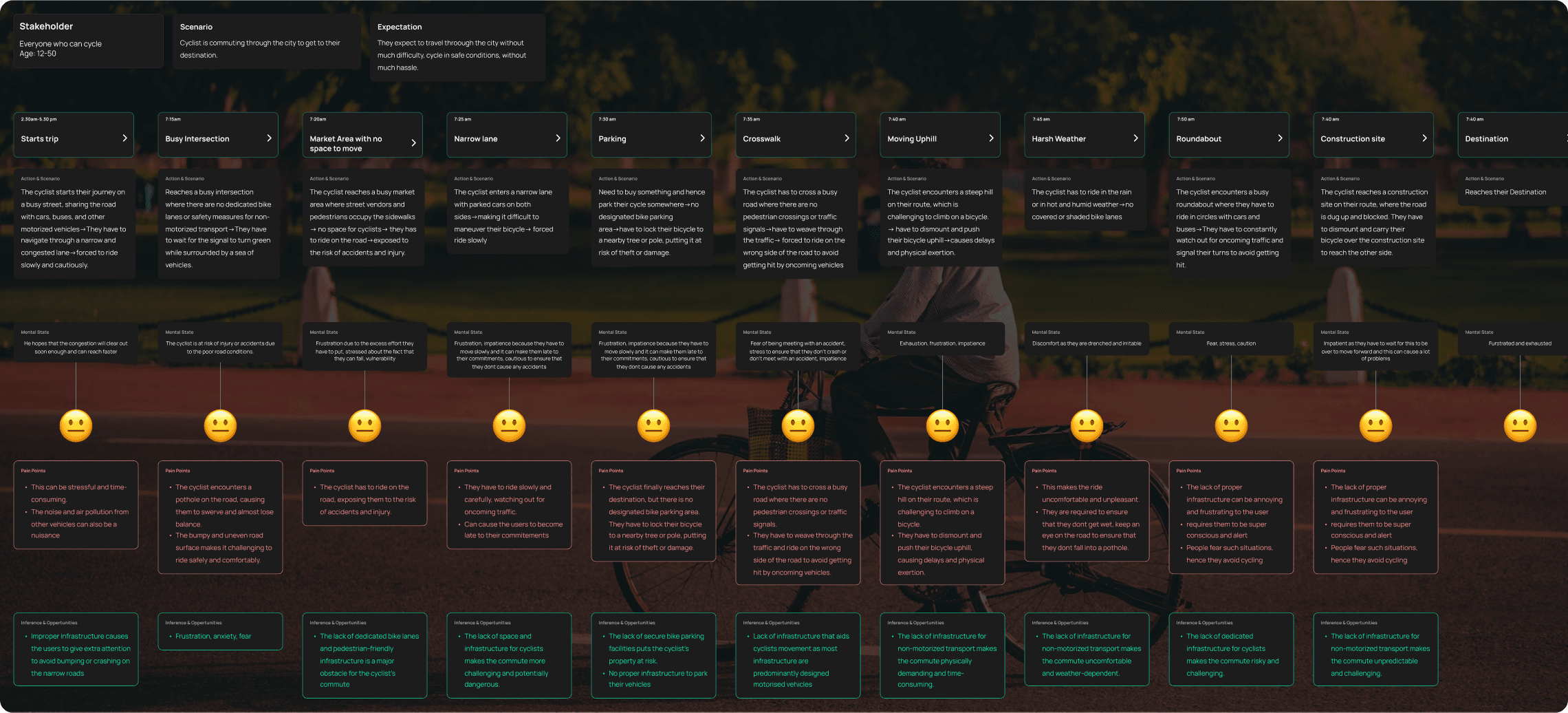
Cyclist User Journey
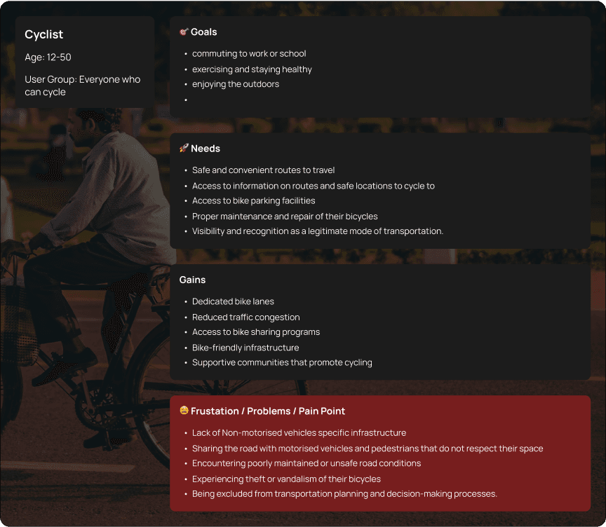
Cyclist User Persona
Problem Definition
We understood that the failure of previous initiatives to manage congestion could be accounted to its singular nature. Previous solutions only focused on a individual part of the problem which meant that every other issue remained problematic and limited the suggested solutions.
Traffic congestion in Bangalore is a multifaceted issue. We identified the following primary aspects that when tackled together, could eventually mitigate congestion.
Induced Demand
Roads become congested with cars at maximum capacity
Government initiatives to increase car- centric infrastructure to accommodate more cars and ease traffic.
Vehicle travel increases due to the new efficient roadways promoting connectivity
1
2
3

Poor Non-Motorized Transport Infrastructure
The infrastructure supporting non motorized transport is commonly not properly maintained, generally unsafe, confusing to navigate or non existent to favor the passage of motorized vehicles. This along with poor planning of districts in Bangalore has led to users relying on private vehicles more than traditional modes like walking, cycling etc. as commercial, community, entertainment and work areas are far apart.
Poor Public Transport
Public transport in the city, although functional is only able to meet its bare requirement of getting passengers from one place to the next. The over crowding, scarce availability of bus fleets, overall lack of maintenance and information transparency, among other problems have pushed away users and forced them to either use private vehicles or play their luck by taking a barely functional public bus.
Brainstorming & idea bucketing
Ideation Process:
We converted the major issues into core requirements that needed to be addressed and ideated upon in the brainstorming phase. This step helped us align our ideas with the core problems instead of getting sidetracked.
Numerous ideas were generated under each requirement and then grouped and combined to form concepts based on how well the different ideas worked together as a system.
The concepts are then evaluated against the requirements to see how well the requirements are being met as well as how feasible they were.
How do we solve this?
A systemic approach:
Due to the numerous interconnected problems that fall under traffic congestion, we decided that a system based solution is the only viable option to go forward successfully.
By doing so we were able to focus on all the major problems of our varied stakeholders and make sure that these sub solutions worked together in harmony with each other.
This also allowed us to design an intervention that was complex and flexible to the unique use cases in different sections around the city.
Therefore our main solution would be multiple solutions working together.
Improvements on Public Transport
Improvements on Infrastructure
Integration of Shared Spaces
Concept 5
This solution concept proposes several ideas to improve the urban environment for pedestrians and cyclists. It suggests using lights on railings that switch on when they sense people near, creating public spaces for spontaneous activities, and carpool zones near seating areas.
The concept also includes using solar-powered streetlights that charge during the day and automatically turn on at night to reduce energy consumption and improve visibility. To promote community engagement, the proposal suggests using pop-up parklets and street art installations to temporarily transform roadways and sidewalks into vibrant public spaces.
The proposal also highlights the importance of proper lighting along the route to ensure safety and visibility, especially at night. Additionally, mobile apps can provide information on road closures, lane restrictions, and other traffic-related issues, allowing non-motorized transportation. Finally, the proposal suggests making public transport more accessible and comfortable for commuters.


Encouraging communities to attach identities to their streets and keep maintain the greenery either by keeping their surroundings clean or setting up green communities with hydroponic plants
SOS buttons provided at accessible locations
Underground/ on ground parking zones for motorized vehicles that will be ticketed.
Smart roofs that to adjust to the weather, seating areas for the general public and tansit users
More retail and commercial shops that they can browse through as they walk, encourage street performances and art projects that are displayed on the streets, that makes the walk more pleasurable experience
Encouraging communities to attach identities to their streets and keep maintain the greenery either by keeping their surroundings clean or setting up green communities with hydroponic plants
SOS buttons provided at accessible locations
Leveled, textured paths that increase friction along with Clear demarcation of road humps or irregularities on the path, accompanied by street lights powered by solar power
Railing to ensure security, and divide the crowd to avoid huddling in a single location accessorised by Lights on railings that switch on when they sense people near
Clip-on radar checker and lights for cyclists, and convex mirrors to ensure the users can be careful and sharp turnings
Poles that provide short quick vibrations when the signal is red
Kiosks where individuals can access information about public transport, update their transportation card, and access other important information
Disperse ample dustbins under benches where people can put their waste
Inclined seats with drainage holes to make sure they dry quickly after a rain spell
Seats and minimal grates around greenery that catch fallen leaves and fruit in the area to minimize spilling and ease cleanup
Cameras detecting and taxing vehicles that are going above the speed limit
traffic signals adapting to the traffic and controlling traffic.
Create multi-level pedestrian bridges that connect buildings and streets, allowing people to safely and easily cross over busy roads and public transport lanes.
Greenery and Landscaping
1.1. Greenery
1.2. Engagement
1.3. Functionality
2. Infrastructure and Amenities
2.1. Comfort
2.2. Public Necessities
2.3. Mobile Segregation & Parking
3. Entertainment and Amusement
3.1. Street Persona
3.2. Connection
3.3. Incentive
4. Safety
4.1. Emergency communication and response
4.2. Pedestrian and cyclist safety
4.3. General Safety
5. Accessibility
5.1. Non-motorized vehicles
5.2. Blind
5.3. Disabled
5.4. Poor
5.5. General
6. Information Transparency
6.1. SIgnages
6.2. Displays
6.3. Application
Hygiene
7.1. Disinfection
7.2. Waste Management
8. Shared space
8.1. Pedestrian-First
8.2. Mobile- Second
8.3. Transport Synergy
Selected Concept
Problem statements
Lack of proper planning of city infrastructure and transportation networks that prioritize non motorized modes of transport lead the population to naturally become dependent on motorized transport for meet their daily needs, which ultimately led to the increased number of private vehicles that exceeded road capacity and consequently cause congestion
People are hesitant to use the public transport because of poor implementation of schedule, accessibility and unwillingness to spend excess time commuting, hence refrain from using these services.
consolidated Problems
Poor Non Motorized Transport Infrastructure
Lack of proper segregation of pathways and amenities for pedestrians and cyclists
Poor Public Transport
Overcrowding, Inefficient payment systems, irregular scheduling and faulty bus services.
Lack of Safety Measures
No safety protocols, segregation or guidance for users to navigate commuting spaces.
Lack of Effective Information Transparency
Inaccurate information, overlapping modes of travel routes and information overload.
Lack of Regular Maintenance
General lack of maintenance that leads to damage of roads and amenities made available to travellers.
Lack of Accessibility
Lack of accessibility in remote areas, narrow pathways, disadvantaged sections of stakeholders.
Testing

90%
Usage of signs & designated pedestrian pathways
Requirement
Information Transparency
80%
community approval of pedestrian-centric facilities due to safety & comfort
Requirement
Safety
60%
Increase in non motor transportation via cycles, walking..etc.
Requirement
Shared Space
85%
Usage of amenities surrounded by greenery
Requirement
Greenery & Landscaping
60%
Usage of pedestrian pathways
Requirement
Shared Space
70%
Usage of designated of motor space
Requirement
Shared Space
View Other Projects

Have a project in mind? Let’s talk!


